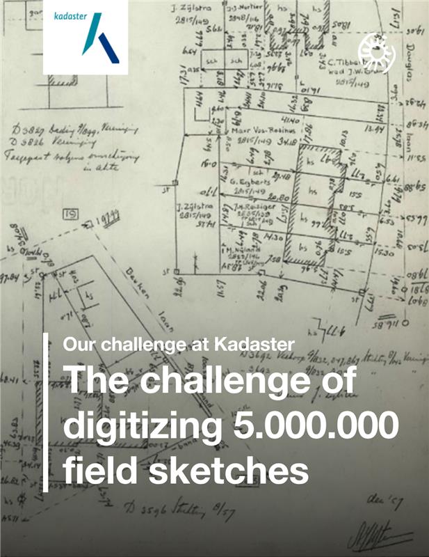
For centuries, Kadaster’s hand-drawn field sketches formed the backbone of land registration in the Netherlands. Rich in detail but time-consuming to process, they needed a digital transformation. With over 5 million sketches waiting to be digitized, Kadaster turned to Sioux to help reimagine the future of cadastral mapping. Here’s how we did it.
The Kadaster maintains the official land registry of the Netherlands. For over two centuries, they’ve documented the layout of the land through detailed field sketches. Maps drawn by surveyors in the field, capturing buildings, roads, waterways and plot boundaries.
But in a modern context, these sketches posed a major challenge. Processing a single sketch – retrieving it, interpreting it, and measuring it in the field – could take up to eight hours. Even manual digitization and vectorization still took around 90 minutes per sketch. With millions of sketches to process, it became clear that a smarter, automated approach was needed. That’s where we came in.
To build a complete, up-to-date digital cadastral map, these sketches needed to be vectorized: transformed from raster scans into accurate digital representations using points, lines and geometry. But this was no straightforward task. Key challenges included:
It quickly became clear that standard solutions couldn’t meet these demands. Kadaster needed more flexibility, more precision and a scalable approach. That’s why we applied a top-down method: we mapped the full process, identified key bottlenecks and defined the steps where AI could add the most value.
We began with a feasibility study to explore whether the vectorization of scanned field sketches could be automated, accurately and at scale. The answer wasn’t black and white. Fully automatic processing proved unfeasible with current technology, but a hybrid approach offered huge potential.
So, we broke the problem down into smaller, manageable subtasks. This allowed us to develop tailored algorithms for each phase of the vectorization process:
Under the hood, we applied a range of cutting-edge techniques, including convolutional neural networks (CNNs) for image recognition, recurrent neural networks (RNNs) for reading text and generative adversarial networks (GANs) to enhance image quality.
Rather than aiming for full automation, we built a semi-automated, human-in-the-loop workflow. The AI does the heavy lifting, while a purpose-built graphical interface allows experts to make quick, precise corrections. Off-the-shelf tools were combined with tailor-made algorithms for maximum flexibility and performance. This hybrid setup dramatically reduced the time required per sketch, from 90 minutes to just 18 minutes.
To support large-scale deployment, we integrated a robust MLOps infrastructure. This ensured scalability, stability and consistent performance across millions of sketches.
The result of our collaboration? A powerful, scalable vectorization pipeline that enabled Kadaster to digitize its vast archive with speed, precision and confidence.
✓ Each sketch digitized over 80% faster
✓ Improved accuracy across millions of data points
✓ A major step toward a national digital cadastral map
But digitizing individual sketches was only part of the solution. The next challenge was stitching them all together into one coherent, country-wide map. That meant aligning borders, correcting overlaps and resolving inconsistencies. In other words: a mathematical puzzle involving nearly a billion variables.
Leveraging our expertise in mathematical optimization and large-scale system design, we helped Kadaster transform a fragmented historical archive into a unified, intelligent mapping system.
"Sioux Technologies truly understands our challenges and is helping us achieve a breakthrough in digitizing this massive and complex body of geo-data."
With this AI-powered system now in place, Kadaster is well on its way to realizing a fully digital and intelligent cadastral map of the Netherlands. And the potential goes far beyond land mapping. The technology behind this solution can be applied in other fields as well.
Think of digital archiving, where historical documents become searchable. Or engineering, where scanned technical drawings need to be vectorized and interpreted. Wherever analog information meets digital demands, this approach delivers.